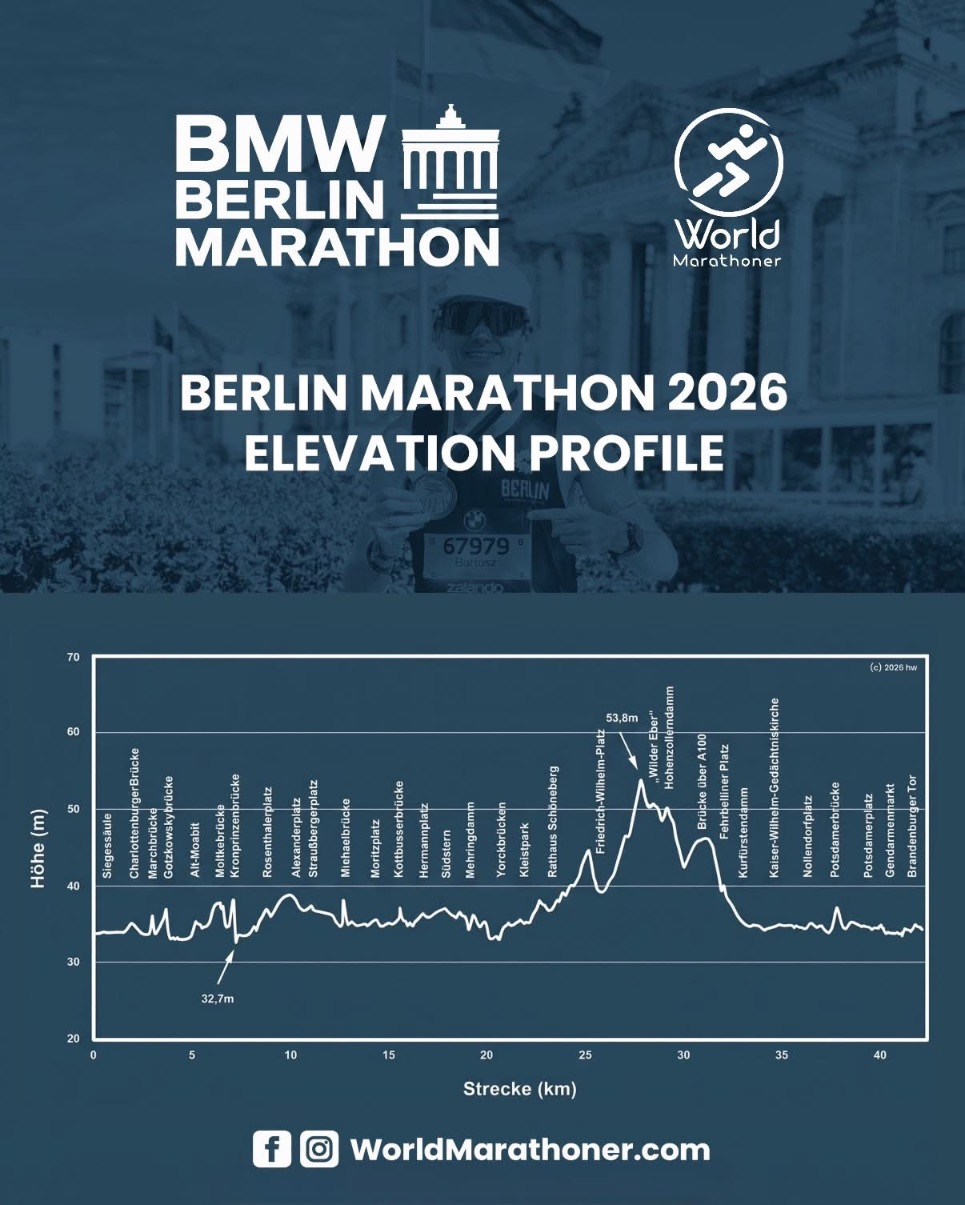
Berlin Marathon 2026: Elevation Profile
The Berlin Marathon has long been known as a place where runners chase fast times. It’s a course where world records have repeatedly been set, and where elite pacing has shaped the direction of the sport. In 2026, more than 56,000 runners are expected on the start line, and understanding the elevation profile is one of the key elements of preparation. Berlin is flat, but not perfectly even. The profile clearly shows that elevation changes are small, yet their placement matters for pacing, strategy and how to distribute effort across the full 42.195 km.
The start sits at roughly 32–35 meters above sea level, visible on the chart as one of the lowest points of the entire course. The opening kilometers are very gentle, with no meaningful climbs. This is the moment to settle into rhythm without fighting for every meter. In practice, the pace here is stable, and the only challenge is the crowd — six waves start at 8:45 a.m., and although the avenue is wide and monumental, it can still feel tight. Siegessäule appears within the first kilometer, a recognizable landmark that does not create any noticeable elevation change. It remains a flat, fast section.
After passing the Victory Column, the course heads toward Charlottenburger Brücke and Charlottenburger Tor. Elevation here hovers around 40 meters, a slight rise but subtle enough that most runners won’t perceive it as a climb. Berlin is known for evenly distributed elevation, with changes so mild that they rarely force pace adjustments. This is one of the reasons the course is considered among the easiest for maintaining consistent splits.
Around the 10 km mark, the profile stabilizes at roughly 40–45 meters. This stretch runs through wide Berlin streets where pace can be held almost like on a track. Alexanderplatz appears here — one of the most recognizable points on the route. Elevation does not exceed 45 meters, meaning the runner is still moving across flat terrain. It’s a segment that supports holding target pace, and for many runners it’s crucial not to push too hard too early and pay for it later.
The most important part of the elevation profile begins later — in the southwest section of the course. This is where the only meaningful climb appears, visible on the chart as a gradual rise toward the area around Friedrich‑Wilhelm‑Platz, which reaches approximately 53.8 meters. It’s the highest point of the marathon. Although the difference from the lowest point is about 20 meters, the climb stretches across several kilometers, making it feel more like a long, steady incline rather than a sudden change. It can gently raise heart rate if pace isn’t controlled. This is the moment to stay alert — it’s easy to lose a few seconds per kilometer here, and hard to get them back later.
After reaching the highest point, the course begins to descend. The profile shows a clear but mild downhill leading toward Rathaus Schöneberg. Elevation drops to around 45 meters, giving runners a brief chance to reset. It’s a good moment to return to target pace if the climb caused a slight slowdown. The descent is gentle enough not to overload the legs, while still allowing natural acceleration without extra effort.
Further along, the profile returns to Berlin’s characteristic flatness. Elevation stabilizes around 40 meters as runners enter the final kilometers toward Brandenburger Tor. This symbolic point does not stand out on the elevation chart, but in reality it’s one of the most emotional moments of the race. Elevation here sits around 38–40 meters, meaning the closing kilometers are fast and ideal for a strong finish. This is where many runners break personal bests, because the elevation profile offers no obstacles.
It’s also worth noting the lowest point of the course, located in the early kilometers — around 32.7 meters. On the chart it appears as a shallow dip. In practice it has no strategic impact, but it highlights how minimal the elevation differences are across the entire marathon. Berlin has no steep climbs, no sharp descents and no sections that require changes in running technique. This predictability is exactly what makes the marathon ideal for runners chasing fast times.
Two practical elements matter when reading the elevation profile. First — the blue line. It marks the exact 42.195 km and is the shortest possible route. With so many gentle bends, following it wherever traffic allows can save valuable seconds. Second — kilometer markers. Berlin works exclusively in kilometers, and each marker has a clock. There are no mile markers anywhere on the course, so runners who think in miles must prepare their splits beforehand. Doing math at threshold pace rarely ends well.
The entire elevation profile of Berlin can be summed up simply: it’s a flat course, but not perfectly level. It has mild rises, one notable climb and a few gentle descents. Everything is spaced out in a way that allows runners to maintain steady rhythm throughout the marathon. This predictability is why Berlin is a place where records are set and where runners from around the world try to push their limits. In 2027, the marathon will take place on September 27, and the elevation profile will remain one of the key elements for anyone aiming to run fast.
News, guides and analysis related to the Berlin Marathon.
Source: Berlin Marathon